How to get to Culra Bothy
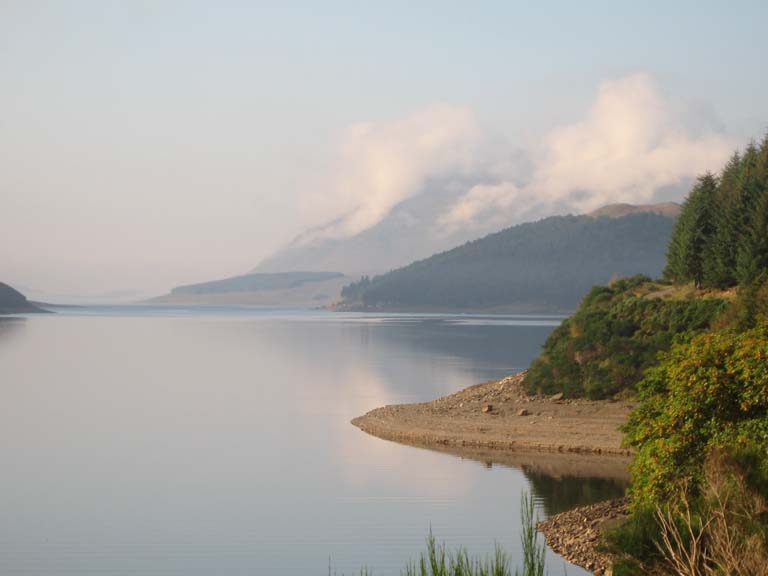
The approach to Culra Bothy along Loch Ericht. The shoulder of Beinn Bheoil is just visible in the mists near the centre of the photograph.
Culra Bothy and the hills around it are on OS Sheet 42 Loch Rannoch. The grid reference for the front porch of the bothy is NN5228476177 to the nearest metre (thanks Les Cunningham and his GPS) or, for most mortals, OS42 523762.
It is quite a long slog in from Dalwhinnie to Culra Bothy by foot, but we've also done it several times by Shank's Pony (coming out at least). One great trip is to take the train to Corrour Station on the Glasgow to Fort William rail line. You can stay overnight at the Station Hostel, or you can stay at the Loch Ossian YHA hostel a couple of km east of the station. From either spot there are lots of fine hills and walks in the neighbourhood. Walking west you can get to Culra by walking over the Beinn Eibhinn/Aonach Beg group or over Ben Alder - or over Bealach Dubh between them. Have a look at the OS map. After a night a Culra it is an easy walk out to Dalwhinnie station and the rail line back to Edinburgh or Glasgow. Or better still there are lots of hills near Culra for the putative munroist!
For us the best way in to Culra is by cycle from Dalwhinnie, and there is a good cycling track right up to the door of the bothy. There are two starting points - one from beside and behind the petrol station or from the railway station. Turn left immediately that you get into Dalwhinnie coming from the South and park before you go under the railway overpass. Or go in to the railway station and turn left just before you get to the station. Drive along parallel to the railway and park just before you get to the gates closing off the railway.
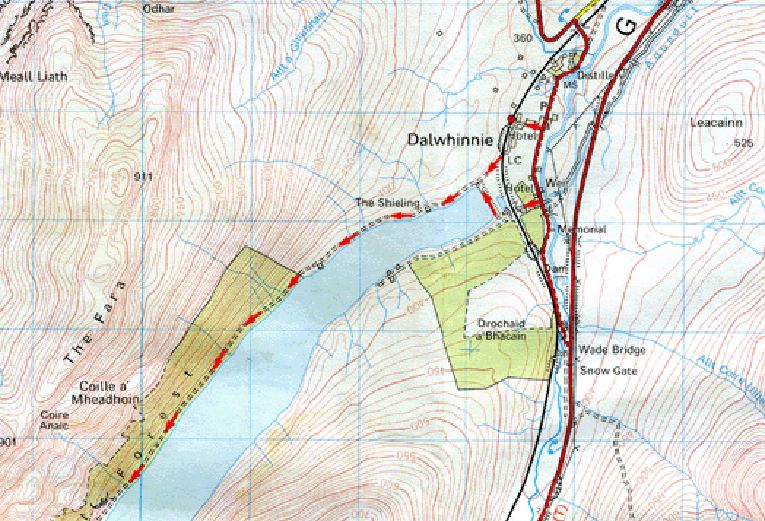
The cycle ride is easy and mostly flat along the shore of Loch Ericht for about five miles - it's good gravel well maintained, and fairly level. After about a mile along the loch you go past the new 'gate house' (with a cycle/pedestrian gate on the right) and, after a second house go a further few miles along the loch. When you are about half-way along Loch Ericht and just before the Disney gatehouse to the Big House, take the right fork up the steep hill to the moor and just keep on going up and westwards. This part of the road is good quality gravel and stone and is easy on a hybrid or mountain bike. On going down the hill towards Loch Pattack there are two possibilities. Either go straight down almost to the Loch and take the left fork around the west side of the loch and over the rope bridge which can be fun with full panniers etc! At the end of the loch there is another fork - again take the left fork and you just go on up hill and down dale till you get there. This is relatively stony but easy enough with a mountain bike but could be the death of something feeble with small tyres. But the better way is the 'short cut' shown on the map below:
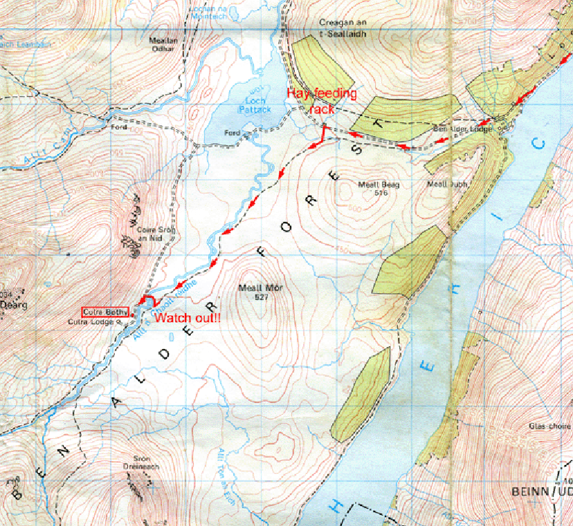
This is a little difficult to find. After you have come up the long hill to the top of the moor, come quite a long way down towards the Loch. About half way between the two forestry plantations on the right you'll see a hay feeding rack for deer and the horses. The building marked on the OS map isn't there anymore, so don't look for it. Opposite the feeding rack there is a small parking area and a narrow track off to the left with a new small bridge crossing a tiny burn. Take this track until you are about 1 km from the bothy. Then you'll see a small sign marked 'Bridge' and a track taking off to the right. Watch out!! It's easy to pass this spot - you have almost to turn back on yourself and the bridge can't be seen from the track. It's quite a bit before you get opposite the bothy. This track crosses a new bridge over the burn (sometimes heavily swollen with rain or meltwater) and then you get on to the main track to the bothy on your left. It takes us about an hour and a half going full pelt either way from or to Dalwhinnie - there is very little altitude rise over the whole but the hump between the two glens is about 200 feet.
The Munros near to Culra are all spectacular and lovely to climb. Once you have made it in as far as the bothy they are all really very near - on a long summers day it is possible to do Ben Alder and Beinn Bheoil after cycling in, another ben or two the next day and cycle out with ease.
Winter is another matter. In winter it could be possible to get in by bike on one day and then end up snow-bound in deep drifts the next. Drumochter Pass, the pass from which the road into the bothy takes off, is the highest in the Highlands over which the railway runs. So conditions can be fierce and life-threatening in winter, and in January and February - and even later - access by bike is impossible.
The track to the bothy from Dalwhinnie is not accessible to the general public by vehicle, except for bringing in supplies by special request to the estate factor. Please do not ask for permission to go in by vehicle as doing so compromises the MBA's position vis-a-vis supplying and maintaining the Bothy. Anyway the point is to get a bit of exercise getting in and out - its only about 1½ hours in by bike and 3-4 hours on foot.
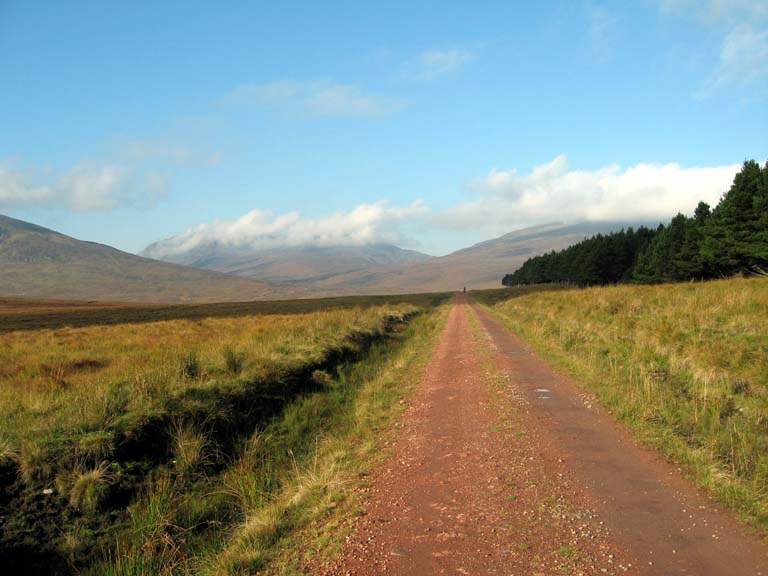
The track to Culra over the moor. This track goes almost east-west and comes down to Loch Pattack (out of view)
It's best to leave the vehicle track near the animal hay feeder about half way between the two forestry plantations (the first plantation is visible in the photo above) and then to take the obvious path off to the left. This crosses over a brand new bridge just before the bothy and avoids the suspension bridge near Loch Pattack and the subsequent steep rough track from Loch Pattack to the Bothy.
Return to the main section of the Culra Bothy home page
![]()